Interactive Data Zooming Java Applets Series, Part 2
zipdecode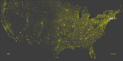 Quick, tell me where this ZIP code is: 54321. Somewhere in the midwest, right? How about this one: 98765? Must be out west, you say. Or how about 12345? Gotta be somewhere in the east.
Everyone knows the basics of ZIP code numbering: lower numbers in the east, higher numbers towards the west. This cool applet will let you zoom in digit-by-digit and see, interactively, how ZIP codes are assigned geographically.
Once the applet is loaded, click on it so that keystrokes are sent to it, and start typing digits. Each digit you type will highlight a portion of the country, each portion getting successively smaller as the ZIP code zooms in on its assigned town/city/area.
Alternatively, there's a Zoom option in the lower right corner which, if turned on, will zoom the map in each time a digit is entered.
Incidentally, of the 3 hypothetical examples I gave, only 12345 seems to be a valid ZIP code (Schenectady, NY)


No comments:
Post a Comment